A Natural Playground with Special Significance
The Wild and Scenic Chattooga is a free-flowing river federally protected for 57 miles through three states and three national forest districts. The river originates in Cashiers, North Carolina and flows downstream through the Nantahala National Forest, continues on through the Chattahoochee-Oconee National Forest in Georgia, and keeps going through the Sumter National Forest in South Carolina where it ends at Lake Tugalo.
Wild and Scenic is an official designation not just descriptive wording. The river is one of a select few waterways that are part of the National Wild and Scenic Rivers System. The Chattooga River was designated “Wild and Scenic” by Congress, which means the river, and a 1/4 mile boundary on each side, will remain natural and undeveloped forever.
The river is not controlled by a dam. Water levels fluctuate depending on the amount of seasonal rainfall that occurs. Generally speaking, spring water levels are higher and by late summer the river is lower with more exposed rocks.

The Chattooga River serves as a boundary between Georgia (Rabun County) and South Carolina (Oconee County).
River Sections
Beginning near the headwaters and going downstream, the Chattooga is classified by sections (stretches of river) and class (difficulty) of rapids. Each section is appropriate for various activities.
- Section I (Burrell’s Ford to Lick Log Creek) This section is 7.5 miles of mostly flat water. It is a popular destination for fly fishing.
- Section II (Hwy. 28 bridge to Earls Ford) This section is nearly 8 miles long and has Class I-II rapids. It’s appropriate for canoeing and beginner kayaking or tubing. Tubing is not allowed below Earls Ford.
- Section III (Earls Ford to Hwy. 76) This 13 mile stretch is popular for rafting and kayaking. There are class II-III rapids. The gradient gets steeper and intensity of rapids increases going downstream. This is one of the commercially rafted sections.
- Section IV (Hwy. 76 to Lake Tugalo) This section is 8.4 miles and has Class II, III, IV, V and VI rapids–much of which is considered intense whitewater. A great stretch for experienced kayakers and high-adventure types. This is the other commercially rafted section.
Getting There: There are two roadways that cross the river, Highway 76 (from South Carolina into Georgia); and Highway 28 (from South Carolina into North Carolina).
Something to note: When the Chattooga River was undergoing Congressional designation, Rabun County officials wanted to appease their local constituents and allowed existing access points into the river to remain open. Cars can drive into Earls Ford and Sandy Ford on the Georgia side. But driving right up to the river is not possible on the South Carolina side.
For rafting guests, recreational paddlers, anglers, hikers, swimmers, etc., the 1/4 mile protected boundary means that all boats, gear, coolers and necessities must be carried to and from the river.
The reward of having this natural buffer is the wonderfully wild and scenic setting visitors experience within the river corridor!
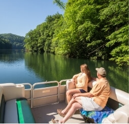
River Tourism
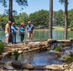
The Wild and Scenic Chattooga River serves as the lifeblood of the local tourism industry, attracting visitors from far and wide seeking adventure and solace amidst nature’s splendor. The river offers a variety of recreational activities, suitable for thrill-seekers and those looking for leisurely experiences.
The river is a popular destination during the summer. We have seen more people visiting the Chattooga River the past several summers than ever before. For this reason, we encourage folks to plan trips throughout the year–specifically in the Spring, Fall and Winter–to lessen the impact on natural outdoor settings. The shoulder seasons are just as wonderful but less crowded and more enjoyable for folks looking to getaway from urban areas.
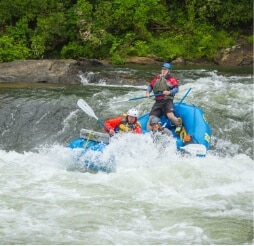
Whitewater Rafting
One of the primary draws of the Chattooga River is its world-class whitewater rafting opportunities. With sections ranging from Class II to Class V rapids, adventurers can embark on pulse-pounding journeys through rapids with names like “Bull Sluice” and “Five Falls,” under the guidance of experienced outfitters.
The Chattooga is the only Wild and Scenic river east of the Mississippi that is commercially rafted. The river is under the jurisdiction of the U.S. Forest Service, and just three companies are permitted to operate on the river. Each company must follow strict guidelines with regards to the time of day, number of trips, and the number of people allowed to go down river each day.
To find out more about commercial outfitters or to plan a private trip, read our post titled: Chattooga River Rafting.
Kayaking and Canoeing
For those preferring a more intimate experience with the river, kayaking and canoeing provide an exhilarating way to explore its meandering bends and hidden coves. Whether navigating calm waters or tackling challenging rapids, paddlers are rewarded with breathtaking scenery at every turn.
Note: If you are planning to float down the river (rafting, paddling, canoeing or kayaking), the Forest Service requires everyone to fill out a permit at self-serve stations located at each put-in. If you go with a commercial outfitter, you will register through them.
Fishing
Excellent trout fishing opportunities. Anglers flock to the Chattooga River in pursuit of its abundant trout population. The river’s cool, clear waters provide an ideal habitat for rainbow, brown, and brook trout, offering a serene setting for fly fishing enthusiasts to test their skills. (A valid SC fishing license is required to fish within the national forests. Read more about fishing regulations and licenses here.)
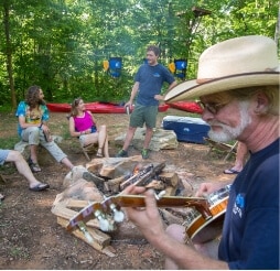
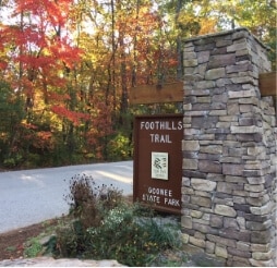
Hiking and Camping
Beyond its waters, the Chattooga River boasts an extensive network of hiking trails that wind through old-growth forests, offering opportunities for exploration and wildlife spotting. Several campgrounds dot the river’s banks, providing a rustic retreat for overnight stays immersed in nature.
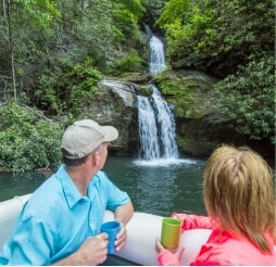
Ecotourism and Conservation
Recognizing the ecological importance of the Chattooga River, ecotourism initiatives and conservation efforts are integral to the local tourism industry. Guided nature walks, educational programs, and volunteer opportunities allow visitors to deepen their appreciation for the river’s biodiversity while contributing to its preservation.
50th Anniversary of Wild and Scenic Status
In 1974 the Chattooga River officially became a Wild and Scenic River. Five decades have passed, and the river setting is much like it was in the 1970s. Its untamed waters flow through diverse landscapes, ranging from tranquil stretches surrounded by dense forests to exhilarating rapids cascading over rugged rocks, creating an unparalleled outdoor playground. The natural setting is a testament to the Wild and Scenic Rivers Act, which has prevented over-use and development of the river, and adjacent watershed areas.
The Wild and Scenic designation ensured the river would remain undeveloped and protected along a 15,432-acre corridor. Specifically: 39.8 miles of the Chattooga River are designated “Wild” which is classified as remote and undeveloped; 14.6 miles of the river are designated “Recreational” where there are access points, roads and bridges within the corridor; and about 2.5 miles of the Chattooga River are designated “Scenic” which falls between the Wild and Recreational level of development.

As a Wild and Scenic River, the Chattooga is preserved in free-flowing condition for the enjoyment of the public. No only is the river protected, it also fosters a thriving tourism industry that celebrates and sustains the river’s splendor for generations to come. Whether seeking adrenaline-fueled adventures or tranquil moments of reflection, the Chattooga River welcomes everyone to explore its untamed waters and pristine wilderness.
External Threats
Although the Chattooga River–and the 1/4 mile surrounding watershed–are federally protected, there are factors at play that impact the natural settings.
Development Upstream
Areas near the headwaters of the Chattooga River are facing large scale development. The pressure to build housing and commercial infrastructure stands to adversely affect water quality and wildlife habitat downstream.
To learn more about the complex issues regarding upstream development, read the Chattooga Currents newsletter from The Chattooga Conservancy.
Ecological Pests
Another threat to the Chattooga River is the Hemlock Woolly Adelgid. This tiny aphid-like insect feeds on native Eastern and Carolina Hemlock trees. The Chattooga River is flanked by huge hemlock trees that have been infested with Woolly Adelgids. The Woolly Adelgid sucks sap from the trees and injects a toxic saliva into the trees causing them to slowly whither and die. Trees that succumb to the pest often fall into the river. Logs and branches can get wedged between rock formations and cause changes to water flowing through rapids along the river.
The non-profit Carolina Hemlocks has partnered with various organizations to locate, treat, record and monitor existing hemlock populations. Read about their efforts here.
Local Scene
Find places to go and points of interest in these towns that border the Chattooga River on the South Carolina side: Long Creek and Mountain Rest.

Author: Chanda Morrison
Chanda contracts with VISIT OCONEE SC to maintain the website, write articles for the blog and produce the monthly newsletter highlighting tourism opportunities. She lives in Mountain Rest and enjoys hiking along, rafting down, and swimming in the Chattooga River any chance she gets.