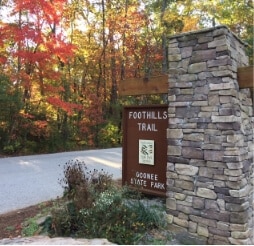
An Extraordinary Opportunity to Explore the Southern Appalachians!
About 77 miles in length, the Foothills Trail is located along the Blue Ridge Escarpment and offers diverse hiking adventures through various landscapes. The trail runs between Oconee State Park and Table Rock State Park. Along the way, you’ll find high rocky outcrops offering expansive views and lush forests bordering cool mountain streams. Elevations range from 1,120 feet at Table Rock State Park to 3,560 feet atop Sassafras Mountain.
Whether you are looking for a long-distance backpacking trip or an exciting day-hike, the Foothills Trail is a great experience!
The westernmost section of the Trail is located in Oconee County, SC, where you’ll wind around 8.5 miles of the Wild and Scenic Chattooga River. Hikers can enjoy panoramic views of the river and opportunities to fish, swim or float along the way.
Every season has its appeal: Spring offers the chance to watch nature come back to life with new leaves and blooming wildflowers. Even on the hottest Summer days, much of the trail winds through the National Forest, so there is abundant shade and opportunities to cool off by the river, streams, or near waterfalls. In the Fall, the temperature cools down, and the forest is aglow with yellow, red, and orange leaves. In Winter, hikers are treated to stunning views through trees that have lost their leaves; and this is the season when insects disappear.
Through-hikers planning to hike the entire trail should expect to spend approximately 5-10 days on the trail. Day-hikers and weekend backpackers can access various trailheads for shorter trips. The user-generated map below is a great way to visualize, plan and prepare for a journey along the Foothills Trail.
Foothills Trail Interactive Map (click to access)
In Oconee County, you can access major trailheads along:
- SC Hwy. 130
- SC Hwy. 107
- Oconee State Park
History of the Trail
In the 1960s, a group of hiking enthusiasts joined together to get support for creating and improving a series of trails in the Upstate region of South Carolina. The vision was to link Oconee State Park (in Oconee County) to Table Rock State Park (in Pickens County).
The Foothills Trail Conference was established in May 1974 as a non-profit 501 (c) (3) organization to facilitate “the coordination of groups and individuals interested in advancing, completion, use and maintenance of the Foothills Trail.” The trail was made possible with the help of Duke Energy, the U.S.Forest Service, South Carolina’s State Parks Department, the Sierra Club, many landowners, and numerous volunteers. A system of well-marked trails was established through these partnerships, which allowed public access to over seventy-six miles of forested land.
The main trail was completed in the early 1980s. Since then, the Foothills Trail has grown to include more than thirty miles of spur trails connected to the original seventy-six miles. From the Foothills Trail, hikers can get to waterfalls, overlooks, campsites, and breathtaking scenic beauty found along the way! Read more about the trail’s history here.
Backpacker magazine rated the Foothills Trail as “one of the best long trails [fifty plus miles] in the country.”
Foothills Trail Conservancy
Formerly known as the Foothills Trail Conference, the name changed to the Foothills Trail Conservancy in November 2018. This member-driven organization is dedicated to cleaning, maintaining, and exploring routes along the Foothills Trail. The FTC meets annually to attend lectures and presentations, gather for meals, and enjoy active fellowship during clean-up events and maintenance workdays. FTC members and volunteers, including the Boy Scouts and Girl Scouts, work together to maintain the trail. They build bridges and benches and contribute in a variety of ways to enhance the Trail.
Foothills Trail Conservancy promotes and supports the trail through memberships and proceeds from literature sales. The Foothills Trail Map and Geology Guide to the Foothills Trail are available to purchase online.
 The Peregrine Award
Hikers who complete all 77 miles of The Foothills Trail—from Oconee State Park to Table Rock State Park are eligible to receive this award from the Foothills Trail Conservancy. For more details or to apply for the Peregrine Award, go here.
The award was started in 2011 in honor of longtime FTC member Heyward Douglass. The word “peregrine” comes from the Spanish word “peregrino,” which means pilgrim. Peregrine is also the name of one of Heyward’s favorite birds. Fun Fact: Heyward Douglass was instrumental in reintroducing the Peregrine Falcon to the mountains of Upstate South Carolina.
Before you go
The Foothills Trail offers hikes that are appropriate for all skill levels, from easy to strenuous. Obviously, you’ll be out in nature, where there are inherent risks.
Keep in mind:
- Take plenty of water.
- Wear layers of clothing.
- Wear appropriate shoes, not flip-flops or slip-ons.
- Dark comes quickly in the mountains; unless you’re camping, allow enough time to get back to the trailhead.
- Seasonal hunting is allowed in surrounding areas; be sure to stick to mark trails and wear bright clothing.
- Don’t climb on rocks, wade, or swim above waterfalls; emergency rescue help is not close by.
- Cell reception is very patchy in many areas of the National Forest.
- Let friends or family know where you’re going and approximately when you expect to return.
- We love showcasing Instagram photos and videos ????. If you have some to share, please mention @VisitoconeeSC and comment with #YesVisitOconeeSC.
- Tags: Biking, Hiking, Nature, Recreation, Waterfalls
-
Post Author: Ken Sloan

